Friday, 12 April 2013

Post 8: Power of Lincoln Memorial Reflecting Pool, Washington DC


Today’s blog will be the last one of the year, which will examine National Mall in Washington D.C. Thank you to everyone that checked out my blog and hopefully it offered good insight into some of the most important historic sites around the world.  This post will specifically examine the Lincoln Memorial Reflecting Pool, examining the ‘power’ constructs.  The analysis will be done using both traditional methods and perspective from Margaret Farrar.

 The reflecting pool is a large rectangular pool located east of the Lincoln Memorial, on the National Mall.  It is beautiful area lined by trees and offer visitors an area to sit.  In itself the Reflecting Pool is large, expanding over one-third of a kilometre.  Its expansive nature in itself suggest the power of the space, designed for people to congregate in.  Although, the architecture is simple and has limited unique design patterns to show power, tools set out by Farrar can be used to state otherwise.

Using the work of Farrar we can consider the power constructs that exist between the people and the subject.  She suggests that too much focus is place on either the buildings or the rulers, but not what comes between.  In this regard to this, we note the Reflecting Pool is a good example of space between the rulers and major buildings.  This Reflecting Pool offers significance because it is a place where the average person come to view those in power speak or to view the Lincoln Memorial.  Furthermore, Farrar suggests that instead of focusing on certain groups, analysis should examine the spatiosymbolic order, which reflects how economic, political, and cultural resources are concentrated and communicated through the built environment.  In this case we again note that the Reflecting Pool as a corridor space that controls the flow of people.  The wide areas is a commonly found form, know because Americans ‘built big’ to reflect power.  These forms are symbolic to the segregated power, races, and socio-economics that exist in American history.  Overall, the Lincoln Memorial Reflecting Pool has significant power constructs that would not come to light without the methods suggested by Farrar.

Friday, 29 March 2013

Post 7: The Laws of the Indies


Today’s blog is taking a step in a different direction; it is not your typical virtual tour through an ancient site.  This post examines the Laws of the Indies created by the Spanish, which are known as “Settlement Ordinances”.  The Laws of the Indies are much like modern land zoning legislation by-laws.  They set out different land-uses, types of architecture, and shape the colonies in a planned manner.  Using the “The Spanish-American Grid Plan, An Urban Bureaucratic Form”, written by Graziano Gasparini, this post examines the reason for creating the document. 
It is important to understand why these laws were made.  There are many reasons rulers decide to introduce them.  One of the major ones was to control the people, through the use of the grid pattern.  This set the hierarchy of classes with the rulers and settlers living in the center (plaza, churches, and government buildings).  The lowest classes live near the outskirts, with limited knowledge and access to certain area of the city.  This form of land planning was also useful to fortify the area, protecting the people in power and controlling the flow of attackers.  The urban form shows the coming together of cultures, military control, power, and organization.

After understanding why the Spanish ruler created these laws, it is important to understand how they drafted the laws to create these cities.  The laws controlled what lands could be settled, the type structures and who owned the lands, and how the sites were planned.  The restrictions on land settlement was important for many reasons, ranging from proximity to water ways for trade and fortification to isolation from native population to prevent the spread of disease and cultural mixing.  Furthermore, the laws set out how certain lands must be used, such as for development or for agricultural purposes.  Lastly, by-laws largely created the grid plan design without directly stating the use of it.  These practices show a calculated and mathematical approach to succeeding.

It is particularly interesting to note how the principals created a more uniformed architectural form for the Spanish colonies.  It was an important method of creating an empire without the ruler ever visiting the colonies.  These laws led to the Spanish having advanced urban form through the empire.

Friday, 22 March 2013

Post 6: Change in Urbanism & Architecture: Granada vs. Santa Fe de Granada


Transformations in urban design and architecture are always interesting to witness.  Recently, we have witnessed a shift from urban sprawl and suburbia to a more walkable and higher density lifestyle. Today’s discussion will examine another shift in urbanism and architecture that can be realized by comparing Granada and Santa Fe de Granada of the 15th Century. 

Granada was a Medieval settled city controlled by Islamic culture, until re-conquered by the Spanish Catholics.  Its old age of settlement is largely the reason it had an ‘organic’ layout.  During this period of time, Santa Fe de Granada was newly founded and represents the urban form and architecture of its era well (grid-planning).  

Granada
Granada has the ‘organic’ form, which is a similar form of urbanism as that of Rome.  Conversely, Santa Fe de Granada we see the grid-pattern, which is similar to that of Timgad or modern cities of North America.  The site also has more fortified design than Granada, most likely designed to avoid future conflict and to show the militaristic control.  Furthermore, the grid offers many control measures that it did in Timgad.  Santa Fe was able to control the flow of people and protect the most important at the center, making the urban planning an integral part of design. As for the architecture, the Spanish used roman styles, typically a mix between Gothic and renaissance styles.  We note the important building are located at the center, usually the largest building being the Catholic church. 

Santa Fe de Granada 
We know the Spanish realized the importance of urban planning, through written artifacts.  Often the design was considered more relevant than the people, in order to protect themselves. Therefore, it is not surprising that using the most advanced built form were thought not only to show the power but also as the key method to preventing being taken over by other rulers.  This is likely the reason why Santa Fe de Granada became the new center, using proper planning and fortification.

Friday, 8 March 2013

Blog Post 5: Tenochtitlan vs. Mexico City


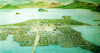
Today’s post examines modern day Mexico City, which was originally Tenochtitlan, the capital city of Aztec culture.  The best way to compare the two sites is with an aerial shot from Google Earth and historic replication of Tenochtitlan (see images below).  I hope to explain the relationship between the size and scale of the two sites, reasoning for building the Spanish colony on top of the Aztec city, and importance of such an undertaking.


Aztec City

Mexico City

To begin we will examine the relationship between the historic and modern site.  The site was considered a strange geographic location to be settled due to marshy soil and proneness to earthquakes. However, they believed that the symbology of an eagle eating a bird on top of a cactus was god choosing it as a place the Aztecs must settle.  The Aztec city was large in size housing approximately 200,000 people in 10 square kilometers.  The old city had bridges that could be raised to protect them from invaders.  Today, Mexico City has been build on top of the ruins of the Aztec city.  We also notice the water has been drained and Mexico City is much more sprawled out form compared to the original settlement.  Largely, the extended cityscape is due to the 8.8 million that live in the City and 21.2 million that live in the Metropolitan of Mexico.

Next, two questions come to mind: “why did the Spanish decide this location to build a colony?” and “What is its significance?”  Given the time frame, the Aztecs had clearly accomplished something great.  The size and control of Tenochtitlan was impressive, and was likely the reason the Spanish created Mexico City on top of it.  They knew that the city would be able to provide room for many people given the geographic size and relatively high-density design.  Furthermore, the island was barricaded from enemies and other people.  This was a very attractive tool to control the population and fortify its civilians from enemies. The majority of the Tenochtitlan architecture was destroyed and built over, to clearly display the wealth and new power of Cortes.  Mexico City has clearly benefited from the location, today being one of the largest cities in the world.

Saturday, 2 March 2013

Blog Post 4: Comparison of: Pyramid B (Tula) & Temple of Warriors (Chichen Itza)


Academics traditionally suggested that Chichen Itza was invaded and controlled by the Toltecs of Tula, due to the similarities in the architectural form.  Recently, this has been questioned, and the theory has changed to suggest that the two cities were simply trade partners.  Today’s post will examine the similarities and differences that exist between Pyramid B at Tula and the Temple of the Warriors at Chichen Itza.  With the use of modern technology, the virtual tour will allow me to contrast both sites using both visual cues and historical references.

Historically speaking, in the 19th century similarities were notice between the Chichen Itza and Tula sites.  By the 20th Century, parallels were made based upon the building plans, sculptural forms, and iconographic motifs.  Later, the similarities were thought to exist because of political ties, collaboration between the two rulers, and commercial exchange.

Columns,  Temple of Warriors
 Columns,  Pyramid B


The first major architectural similarity was the feathered serpent doorway columns, which were stated to be “almost an exact reproduction of the Toltec column we unearthed at Tula”.  Also, the round and square columns surrounding the Temple of Warriors depict Toltex warriors, making it obvious that the two sites are related to each other. The plan of both Pyramid B and the Temple of Warriors is nearly an exact replica.  Comparing the two sites we notice they both are terraced or have a step-up design.  Also, both have a stairway to the roof, which allows for easy access.  The flat roof design is another common planning feature. We notice carvings and designs that signify influence of war and religion in both sites. In any case, if they were invaded or just trading partners, we notice significant Toltecian influence on Chichen Itza.


Temple of Warriors, Chichen Itza


Pyramid B, Toltecs

The major differences are limited.  The scale is large in both cases, but the Temple of Warrior has about 200 columns surrounding it while Pyramid B has only 100.  This could suggest the importance and power of the builders. Furthermore, the serpent columns on the roof were used as structural beams for the Pyramid B, while simply as symbolic structures at the Temple of Warriors.  Overall, it should be apparent that the similarities show a strong relationship between the Toltecs of Tula and the Chichen Itza cultures, which much out way the few differences that exist.